Please use the navigation menu at bottom the Page
MenuGoHere
favicongohere
AMHERST STATE PARK

Geological History of Amherst State Park
That's the history; the problems are today.
Homes in the towns of Amherst and the Tonawandas have been most in the news with over 500 houses settling into this ooze and a state estimate of almost $5 million in damages so far. But other buildings located in the wetlands left by this Pleistocene lake may some day soon face similar difficulties.
Much has been reported about remediation of these serious current problems but too little attention is being given to prevention of the same kind of disasters in the future.
Unfortunately, our state and local governments have failed us. New York, for example, is behind all New England states in its definition of wetlands. Because of a 2001 Supreme Court ruling, the Federal government now only protects wetlands connected to tidal, interstate and navigable water bodies. So-called "isolated wetlands", defined as those not so connected (and thus most of them), are now protected by New York only when they are 12.4 acres or greater or "of unusual local importance." No other state in the Northeast has a similar acreage requirement and a national estimate indicates that between one-fifth and one-half of all wetlands are less than 12.4 acres.
Local builders and the municipalities that cater to them have taken advantage of such requirements to develop housing projects in areas with foreseeable problems and without notifying the homebuyers.
That's the bad news; happily, there is good news as well.
Much to the credit of the Sierra Club and other conservation organizations, a bill (A7905-S4480) is, as I write, working its way though the state legislature to address this and other shortcomings in our wetlands protection laws. It has already passed the Assembly with only a single "No" vote recorded. The same conservationists together with organizations like the Audubon Society are, as of this writing, pressing hard for Senate consideration and approval.
This bill would afford protection to New York wetlands of at least one acre and regulate them if they meet the environmental criteria, regardless of whether they appear on a wetland map. So-called "grandfathering" of subdivisions that are not yet built, but that were proposed prior to 1975 to be developed in wetlands, will be eliminated. These are the loopholes in current laws that allow homes to be built in wetlands and sold to unsuspecting buyers.
Given the sad recent disclosures of legislative impropriety, our representatives need to work to regain moral standing. Passing this bill to protect hundreds of future homeowners can represent a small but important step in that direction. Whether or not this bill makes it through this legislative session, it is most worthwhile and I hope that it will eventually be signed into law by our governor. -- Gerry Rising

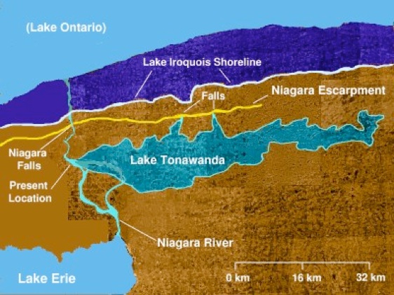
Blame it on Lake Tonawanda.
Turn time back 11,500 years and look down on western New York. Then more slowly wind forward again perhaps a hundred years at a time. You'll see the last of the half-mile thick Wisconsonian ice sheet retreat through the area. First the melting glacier will create Lake Iroquois, the beginning of what will later become Lake Ontario. But then as the glacier backs still further to the north and the water level drops, a smaller lake will form between two east-west ridges, the Niagara escarpment and the Onondaga escarpment. That long shallow pond, rarely more than thirty feet deep and a few miles wide but extending all the way from Lewiston east to Holley, was Lake Tonawanda.
Everyone assumes they know the Niagara escarpment. That's the cliff over which Niagara Falls drops. But what fewer of us understand is that it extends east and west from there as well. You can dine atop it at Schimschack's Restaurant in Pekin or follow it along the north edge of Lockport. The Onondaga escarpment is less evident. One of its most obvious outcrops is in the Escarpment Sanctuary along Greiner Road in Clarence.
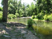
Lake Tonawanda pooled in the flat region between those two ridges roughly centered on what is now Tonawanda Creek between North Tonawanda and the Iroquois National Wildlife Refuge.
As your time machine continues to reel forward you'll see that lake slowly dry up, leaving layer upon layer of oozy sediment, some of that soft admixture of sand, silt and clays still later turning into a kind of quicksand trap for homes built in those wetland areas.


AmherstStatePark.org
AMCNT Web Design Copyright 2011-15 ©
All Rights Reserved